The U. S. Rectangular Survey
From 20th Century History of Springfield and Clark County, Ohio by Hon. William A. Rockel
Chicago: Biographical Publishing Co., 1908
"The struggle for independence of the thirteen American colonies with Great Britain, although a successful one, left the colonies with a heavy burden of debt to pay. The fact, however, that several of the colonies (now states had an interest in what) was then known as the Northwest Territory, proved one of the most powerful influences which kept the new born nation from dropping to pieces, and a fruitful means to assist in clearing off the burden of debt.
The four states, Massachusetts, Connecticut, New York and Virginia, which claimed all the land north of the Ohio River, west to the Mississippi, agreed to give it to the United States, to be disposed of for the common good, and in 1787 Congress passed an ordinance for the government of this territory, and also for establishing a definite method for the survey and sale of these lands, which were now designated as "Public Lands."
The plan arranged by James Mansfield, surveyor general of the Northwest Territory, adopted by Congress in 1802, and called the United States Rectangular Survey, may be briefly described as follows:
First, a north and south line is run through the tract determined upon to be surveyed. This line begins at some prominent or easily distinguished point, and is designated as a "principal meridian." Then a line running east and west, at right angles with the first line, is run through the tract, called the "base line."
The first principal meridian west of Washington is the west boundary of Ohio, which was run north from the mouth of the Great Miami river. It is 80° 51' longitude west from Greenwich.
Lines are then run north and south parallel to the principal meridian, and six miles apart, which divide the territory into long north and south strips, called ranges, which are numbered in their order, 1, 2, etc., east of the meridian, also the same west of it. Across these are run lines six miles apart, parallel to the base line, cutting the territory into long east and west strips called Towns, and these are numbered north and south from the Base Line.
By this "cross-lining" the territory is divided into squares, six miles on a side. Each of these squares is a congressional township. Such "townships" sometimes, but often do not, correspond to the civil townships, which are known by popular names. The only designation of congressional townships is their range and town numbers.
After the tract is thus surveyed into townships sLx miles square, the townships are divided into thirty-six tracts, called "sections," each containing one square mile, more or less.
The sections are run off very much as were the townships, using each township's east range line and south town line as bases. Commencing one mile west of the southeast corner of the township, the surveyor runs north a mile, then east a mile to the east range line and corrects back to the northwest corner of the section. He sets a quarter post (or half mile post) on the west line of the section at forty chains north of the starting point, and sets the quarter post on the north line of each section half way between the northwest and northeast section corners. The surveyor proceeds to run off the remaining sections on the east tier, up to the north line of the township, placing the last section corner where his north and south line intersects that north town line, whether this point is east or west of the section corner previously established in the township survey. The distance between the two corners, if any, is called the "jog," and is recorded.
The government sub-divisions of the section (although they are not actually surveyed by the government surveyor) by which the lands are sold, are "quarter" sections or 160 acres, "half-quarter" sections or 80 acres, and "quarter-quarter" sections or 40 acres. The section is divided into quarters by running a straight line north and south, and one east and west between the quarter posts on the sides of the section. The quarter sections are "halved" by running a straight line north and south or east and west (whichever way it is wished to divide it) from points midway by measurement of opposite sides. The quarter sections are quartered by running lines north and south and east and west between points at the center of each side of the quarter section. Other smaller sub-division can be made on the same principle.
It will be seen from this that if a section is perfectly square and contains the exact number of acres, that this method would sub-divide it into tracts of equal areas, but it hardly ever occurs that a section is exactly square or contains the exact number of acres. Consequently it almost always occurs that the sub-divisions will differ more or less in quantity.
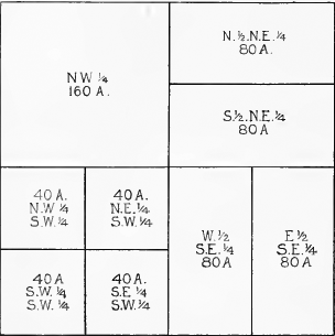
Yet the government has established this as the only method by which the sub-divisions shall be made, and making the eight corners established on the exterior lines of each section "the corners," however incorrect they may be.
The sub-divisions of the section in the preceding diagram, as it is divided into the "Government Descriptions," are each described in brief on the diagram.